OFFICIAL STATEMENT #2
Active Tropical Wave Now Has Reduced Chances of Development
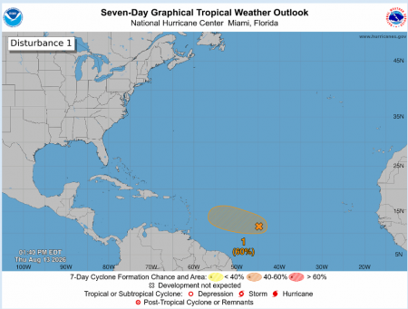
The Trinidad and Tobago Meteorological Service (TTMS) continues to monitor an active Tropical Wave in the Central Tropical Atlantic, located 1400 km east of the Lesser Antilles.
As at 2 pm, Thursday 13th August 2026, showers and thunderstorms associated with this tropical wave have become less organized and the system no longer has a closed circulation. There is now a medium chance (60%) of development into a Tropical Depression over the next two (2) to seven (7) days, as the system is expected to move into a region of unfavourable conditions for further strengthening. Regardless of development, this tropical wave is expected to affect the Lesser Antilles from late Friday night into Saturday, with the potential for areas of heavy rainfall and gusty winds to favour the northern Windward islands.
THERE ARE CURRENTLY NO WATCHES OR WARNINGS IN EFFECT FOR TRINIDAD AND TOBAGO.
The TTMS will issue an update to this statement at 2:00 pm tomorrow, Friday 14th August, 2026 or earlier, if there are significant changes to this system. As always, pay close attention to information being issued by the TTMS by visiting www.metoffice.gov.tt, downloading our mobile app (search: TT Met Office) and following us on X, Facebook and Instagram.
The following graphic is courtesy the NHC: https://www.nhc.noaa.gov/